Showing posts with label Erie Canal. Show all posts

Monday, August 26, 2019

Bank or Canal?


by Susan Zehnder, Education Director

This summer, groups of local students visited the Chemung Valley History Museum. They looked for museum artifacts and documents on a scavenger hunt; heard the true story of the building’s exploding vault (see The Exploding Vault published January 11, 2016); and toured our new exhibit Getting Around: Transportation in Chemung County. They also challenged their engineering skills by designing, building, and testing simple canal boats.

Sometimes an unexpected question or answer gives us to pause and think about history from a different perspective. One of those moments came as we talked about canal boats. When students heard Chemung Canal, many thought we were talking about the bank. But I’ll bet you back in the 1800s, every kid in the area knew about the Chemung Canal.
 

Drawing of Elmira including canal and boats
  
Brief history of the Canal
Inspired by the robust success of the Erie Canal to the north, plans were made to build a canal between Elmira and Watkins Glen. This would connect Elmira’s Chemung River to the Erie Canal, and tap into the growing wealth and prosperity the canal was beginning to bring to western New York. Supporters of the Chemung Canal petitioned the state legislature who granted them the  go-ahead in 1829. Construction on the canal began July 4, 1830. A fairly modest sum of $300,000 was allocated for the project, which in today’s money would be close to 9 million dollars. The proposed canal would be the least expensive canal to date.

 
Photograph of canal construction
It took three years for construction crews to dig the 20-mile canal. Like other canals, it was shaped like the letter ‘u’ and only four feet deep. It reached twenty-six feet across at the base or bottom of the canal and spanned forty-two feet across at the surface. Canals didn’t need to be deep, because traffic on them consisted of canal barges or flat-bottomed boats. Canals were also fairly narrow because tethered humans, horses or working mules pulled them on towpaths along shore. Initial cargo consisted of lumber and agricultural products from the area until increasing demand for Pennsylvania coal dictated the canal be deepened to accommodate larger boats. To do this, workman simply raised the side banks another two feet. Navigating the Chemung Canal took boats two and a half days. They had to travel through the forty-nine locks situated from Elmira to Watkins Glen.

Chemung canal pathway on right side of map
When active, the canal brought prosperity to the area. However, yearly rains damaged the canal, and by 1878 it fell into disrepair. While the canal had been one of the least expensive to build, it had become one of the most costly to maintain. By this time railroads were shipping goods and moving things faster and farther. The Chemung Canal was abandoned and parts of its rights-of-way sold off.
Barge boats at dock along Chemung Canal

Today, parts of the Catharine Valley Trail follow some of the original Chemung Canal towpaths, and the Clemens Center Parkway navigates another part of the canal’s pathway. Unlike the better known Erie Canal to the north, little physical evidence is left of the 20-mile long canal that started in Elmira. 

This summer and fall various Erie Canal events are taking place. The Erie Canal challenge https://eriecanalway.org/explore/challenge is promoting biking, hiking and walking along the pathway at distances of 15, 90, 180, and 360 miles. Although they don’t mention the Chemung Canal, their website does include where to rent kayaks and places to explore near Watkins Glen and Montour Falls. At both places you can see short parts of the Chemung Canal still visible. Mostly the Chemung Canal is a memory.


This map of the Catharine Valley Trail and link share more Chemung Canal hiking and biking opportunities in the area to explore yourself.

The Bank
The Chemung Canal Bank Company started operations in 1833, the same year the nearby canal opened. The very first bank statement issued ten days after opening showed the bank had assets of $318,525 and deposits of over $10,000. A year later, the bank moved into its first permanent home, on East Water Street, now the site of the Chemung Valley History Museum. One of the bank’s founders, an entrepreneur and financier by the name of John Arnot, had emigrated from Scotland and settled in Elmira. He took over as bank president in 1852, and the bank changed its name to the Chemung Canal Trust Company in 1903.
Former Chemung Canal Bank, now home of The Chemung Valley History Museum

It’s easy to assume everyone knows these things, but for people new to the area-which if we think about it includes young students, history needs to be shared. Keeping that memory fresh is what we do here at the Museum.

Monday, June 10, 2019

A Walk in the Park

by Erin Doane, Curator

It takes less than ten minutes to take a leisurely stroll from one end of the Mark Twain Riverfront Park in Elmira to the other, but there is a lot of history in the six-acre green space. The passive park is a strip of green running from Main Street to Lake Street between Water Street and the Chemung River.

Google Maps view of the Mark Twain Riverfront Park
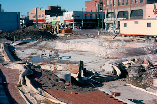
 Construction of the park began in 1975 as part of the “New Elmira” plan following the devastating Flood of 1972. At the time of the flood, Water Street was lined with three- and four-story buildings. While some argued that taking down the buildings would rob the city of businesses, the buildings were in poor condition before the flood and further damage made it impractical to repair them.

Rear of the buildings on Water Street showing flood damage, 1972
By 1975, the buildings along Water Street had been demolished, making way for the new park. Construction of the park was made possible by more than $800,000 in funding from a federal Open Space grant. The name Mark Twain Riverfront Park was proposed by the newly-formed Mark Twain Society in Elmira to help perpetuate the memory of the author in the community. The park was officially dedicated in June 1976 with more than 1,500 people in attendance.

Dedication of Mark Twain Riverfront Park, 1976
Walking through the park today, you will come across features that span more than 150 years of history. Starting at the west end of the park at Main Street, let’s take a virtual walking tour of some of these features.


The Fountain
Fountain dyed pink in support of the Susan G. Komen Race for the Cure held in the middle of May 2019
This fountain has been part of Mark Twain Riverfront Park from the very beginning. Today, it is drained each year for the winter, but back in 1976, the city kept it spouting into December with the hope of creating an ice sculpture after the column of water froze. (I never found a report that this actually happened, though.) Once temperatures dropped enough, they also hoped to freeze over the pond so people could ice skate on it.
Fountain under construction, 1975

Erie Viaduct
Next we come to the Erie Viaduct. While this is not technically one of the park’s features, it does run through it. The builders of the park in the 1970s had to work around this significant structure that was opened in 1934. The $3.2 million project eliminated at grade railroad lines that had cut the city in half.

Dedication of the Erie Viaduct, 1934

Clemens Center Parkway
The next structure we come to on our tour is the Clemens Center Parkway. Just three years after the park opened, the new north-south arterial, another piece of the “New Elmira” plan, cut it nearly in half. In 1979, the entire length of Phase 1 of the arterial, from Pennsylvania Avenue to East Washington Avenue opened to traffic. The name Clemens Center Parkway was chosen because the Clemens Center was one of the most successful projects of “New Elmira,” attracting thousands of people from near and far into downtown.

Clemens Center Parkway, 1979

Chemung Canal Marker
Just on the east side of the Clemens Center Parkway, we find a historic marker for the Chemung Canal. The canal opened in 1833, running from Seneca Lake to the Chemung River, and this was where it connected to the river. In 1878 the canal was abandoned in favor of railroads, which were cheaper, faster, and offered year-round service.


Sailplane Sculpture
Next on our tour, is the sailplane sculpture. The 23-foot tall sculpture of a pair of rotating sailplanes was designed by Ernest Schweizer, retired president of Schweizer Aircraft Corp., to honor Elmira as the Soaring Capital of the World. It was financed by the Elmira Rotary Club in commemoration of the club’s 75th anniversary. They unveiled the new addition to the park on July 4, 1980 and set it into motion.


Citizens & Northern Bank Building
As we continue our virtual walk through the park, we come upon the Citizens & Northern Bank. The building was constructed in 1976 on a plot of land acquired through the Department of Housing and Urban Development, not as part of the Open Space grant that funded the rest of the park because that grant specifically prohibited commercial development. Shepard’s Sirloin Room, run by Morris W. Shepard Jr., opened for business in early 1977 and operated for thirteen years. In 1991, DeFilippo Brothers, Attorneys at Law, moved into the building. When the firm relocated in 2017, Citizens & Northern Bank purchased the building and opened a loan production office there.

Advertisement for Shepard’s Sirloin Room,Star-Gazette, April 27, 1977

Citizens Cascade Fountain
After walking past the bank, we come upon one of the most recognized and most troublesome features of Mark Twain Riverfront Park, the Citizens Cascade Fountain. The sculptural, 35-foot-tall, multi-tiered fountain made of cut granite was dedicated on August 9, 1977 with a crowd of about 100 in attendance. A plaque near the fountain reads: Citizens Cascade. Created to honor the people of Elmira for their spirit and determination to restore and beautify the Queen City after the devastating flood of June 23, 1972. “This is our home town and nothing under God will take it from us.”

Dedication of the Citizens Cascade Fountain, August 9, 1977
The fountain turned out to be the source of constant headaches for the city. The water from the well that was drilled to supply it contained a lot of minerals that clogged the fountain’s pipes and pump within the first year of operation. In 1979, the city had to buy a water softener to keep it running, but it still needed regular repair. Finally, in 2003, the city decided to supply the fountain with municipal instead of well water.


Russell F. Gee Jr. Plaque
Stone with a plaque that reads:  Russell F. Gee Jr.: a community builder
As we wind our way toward the end of our virtual walking tour, we come upon three flagpoles set facing Water Street. Just behind the flagpoles is a small unassuming stone with a brass plaque in honor of Russel F. Gee. Jr., who was a World War II bomber pilot, Elmira City councilman, “Wiz Kid” of downtown development, and president of the Elmira Savings Bank. Gee died suddenly of a heart attack in May 1967 at the age of 48. In November of that year, a newly-constructed mini-park just west of Lake Street was officially named after him.

In 1975, as plans were being made for the creation of Mark Twain Riverfront Park, the Elmira City Council changed a resolution calling for the new park to stretch the entire length of Water Street from Main Street to Lake Street in order to preserve this mini-park. So, this virtual walking tour has, in fact, been through two parks.

View of the park from Lake Street, 2019